Explore Our Professional Drone Services
Midwest Drones provides tailored aerial services to support agriculture, infrastructure, solar energy, and emergency recovery across Ohio and surrounding states.
NDVI maps, stand counts, and elevation models to improve crop performance and input efficiency.
Precision spraying with minimal compaction and targeted treatments for row crops.
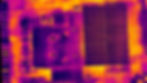
Thermal and visual imaging to detect hotspots, shading, and performance losses.
High-resolution imaging for towers, pipelines, and substations to identify faults.
Thermal drone flights to locate missing people, pets, or livestock quickly and safely.
Why Work With Midwest Drones
Veteran Owned and Operated
We bring professionalism, discipline, and attention to detail to every flight. Midwest Drones is fully licensed and insured.
Fast and Accurate Results
Deliverables are provided within 24 to 48 hours, so you can make informed decisions without delays.
Advanced Aerial Imaging
We use high-resolution thermal and visual sensors to deliver precise data for smarter operations.


